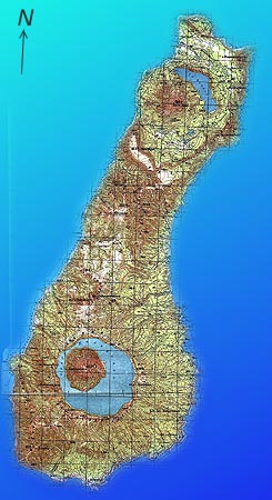
Map of Onekotan
Onekotan is an uninhabited island, although a few Russian border troops are keeping guard in a bay on the Okhotsk Sea. In former time Japanese troops were stationed during WWII, when the Kurile Islands still belonged to Japan, and, after the occupation by Soviet troops in 1945 the Soviet military dominated the precence of human beings. Fishermen and expeditions are frequent, but rare guests.
The vegatation is dominated by dense bushes. I haven't seen any trees. A small strip on the Okhotsk Sea is more or less free of bushes; on the Pacific coast the vegetation grows higher and bushes leave no room for hiking. Due to the military past we were able to walk on some old tracks left by the Soviet troops or, even older, by Japanese troops.
The most terrific problem on Onekotan is the climate. During a period of three weeks we enjoyed only two reasonable good days, on all the remaining days we were treated either by a wet fog or by the heaviest and longest storms I've ever experienced. Without sunshine and in the precence of fog the temperature barely rose above 10 deg C (in August).
The following pages contain photographs of the area around Mt. Krenitsyn and of the coastlines and the northern end (Nemo Peak).