Leh and Markha Valley


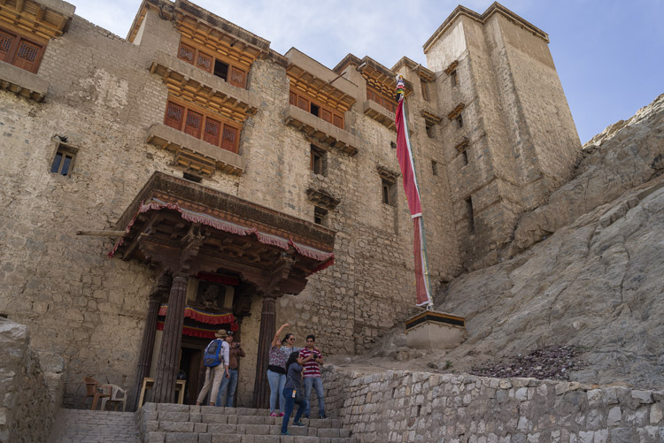
Royal Palace, Entrance

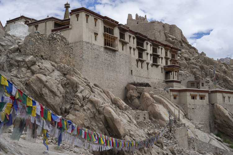
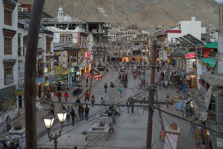
The former residency of the Ladakh King is open to the public. Situated on a hill it provides a wide view over the city of Leh.

Royal Palace

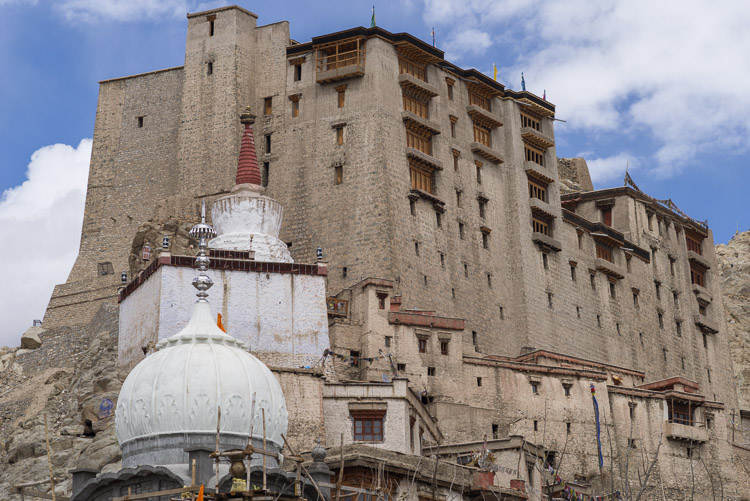
The striking view of the massive multi-story building as seen from the town. Climbing up to the roof may serve as an acclimatization for further adventures in the region.
Leh, King's Residence Leh, King's Residence


Monastery

The Namgyal Tsemo Monastery sits even higher up on the hills than the palace, hence it qualifies for advanced acclimatization.

Roof

As with the palace, it is possible to climb up to the roof, but I wouldn't recommend it to everyone. The ladders leading up to the roof are wobbly enough to turn into a stairway to heaven.
Tsemo Monastery From Tsemo


Evening

The Namgyal Tsemo Monastery at its best - highlighted by the sun on a beautiful evening. Elevation reaches 3700 m, a good 200 m above the city's level.

Tsemo Monastery Tsemo Monastery


Shanti Stupa

This stupa has been built not very long ago, it dates back to 1991. At a little over 3600 m reached via a long staircase it is yet another possibility for acclimatization, and it provides a good look at the city.

Buddah

The Buddha sits on the side of the Stupa and is covered with gold.
Shanti Stupa Shanti Stupa


Spituk Monastery

Just a few kilometers down in the valley near the Indus river. And with a great forbidden view at the airport.

Shey Monastery

Another place to visit near Leh, a King's palace smaller than the one in Leh, coupled with a monastery.
Spituk Monastery Shey Monastery


Stupas

Stupas, also chorten in Tibetan language, are everywhere. By building one you gain a whole lot of benefits according to Buddhist religion, which explains the abundance of these constructs in Buddhist regions. Stupas in the vicinity of Shey Monastery. Their beneficial influence on the local weather is, however, questionable.
Chorten Chorten


Leh at Night

Two donkeys are strolling down the road. Animals are a common sight on roads. Beside cows there is also a rich population of dogs.

Water

Since many buildings are not attached to the water supply, special transportation of fresh water is arranged in drums such as this.
Leh, Zangsti Rd Leh, Water Transport


Roof Top Restaurant

The Main Bazaar Road in Leh, seen from a restaurant on a roof top. Apart from the view, a stay in such a place may turn into a chilly experience in the evening.

Leh

A distant view of the city from Spituk with the airport in the foreground. Leh is a green oasis with both the palace and the Namgyal Tsemo Monastery watching over it.
Leh, Main Bazaar Rd Leh from Spituk


Start at Jingchan

After three days of rest and acclimatization we start our tour in Jingchan at 3400 m. We skipped the first day to avoid walking on a road. However, this part would have delivered some great views of the Indus valley.

House

Yurutse at 4150 m is basically only one house, but a big one indeed. Down in the valley are some places for putting up a tent.
Jingshan Yurutse


Base Camp

The Ganda La Camp at 4340 m is the last chance before the pass for having a tea or to set up a tent.

Mountain

A first summit, the Rumbak Kangri at 5600 m, can be seen shortly before reaching the pass.
Ganda La Base Camp Stok Kangri


Ganda La Pass

Almost at 5000 m, the view goes down the other side, down the Shingo valley. The pass is 4930 m high by the book, 4900 m by the stone on top of the pass, and 4980 m by my own GPS.

From Ganda La Pass


Settlement

Shingo, a settlement in the valley carrying the same name, consists of only two houses. The villages in this region are rather small.

Skyu

At Skyu we finally arrive in the Markha Valley, now at "only" 3400 m and with more oxygen at hand. This spot again shows sign of civilization, a monastery, some houses, and a couple of tea tents. And many stupas.
Shingo Skiu


River

The Markha River is fed by glaciers, melting away in the sun during daytime, while freezing at night. This changes the water level and also its quality. The melt-water carries lots of sediments.

The Valley

A view along a bent in the Markha Valley. The river is nowhere to be seen, we are at higher ground left by a tributary of the Markha River.
Markha River Markha Valley


Campsite

A typical campground at Chumik Hamurja in a moonlit night.

Moon

The moon disappears behind the mountains after having assisted in taking the shot on the left side.
Hamurja at Night Moon


Getting Ready

Locals pack their horses in the morning. A typical group of tourists requires almost the same number of hired staff, guides, cooks, and horsemen, and uses double the number of horses for transport.

Bridge

A crossing over the Markha River. The prayer flags are not only a design feature, they also guarantee the static structure of the bridge. Believe it or not.
Horses Bridge


Steep Walls

The river has switched to clear water mode at a stretch where we have to cross it without a bridge. This causes no problems. At certain places the valley narrows and steep walls and rocks entertain the eye.
Rocks Rocks


Broad Floor

Note the vegetation on the valley floor, the thick layers of sediments, and the bare mountains all around, a typical example of the landscape. The river has turned murky again. There is a tea tent on the left. The snow-topped mountain is the Kang Yaze, making its first appearance in the show.
Markha Valley Kang Yaze


Chicken

A chukar runs, or better, steps for its life with no strategy in mind.

Reptile

This looks more dangerous than it really is. The agame is covered with red stuff around the snout, as if it has just crushed the bones of a hapless tourist. Yet it is only 10-15 cm long.
Chicken Agame


Marmot

Marmots are rare, and I have only seen some near the Ganda La pass. This one is likely going to survive the next winter.

Pika

It looks like a crossing between a rabbit and a lemming. They live above 4000 m in places where I would have expected marmots.
Marmot Hare


Techa Gompa

After the village of Markha a Buddhist temple has been set on top of a rock. In the foreground are stupas, the temple is up on the rock.

Fields

The valley floor is used for agriculture in certain places with good soil, here near Hankar. Probably it was the clearance of stones from these fields that led to the construction of the many stupas.
Techa Gompa Chorten


Up to Nimaling

We have left the Markha Valley and go again along a side valley to Nimaling, the last camp before the pass.

Hoodoos

Erosion has cut a thousand small fairy chimneys into the thick sediments on the valley flanks.
Nimaling Valley To Nimaling


Lake

A small lake at 4600 m with the Kang Yaze (6401 m) behind. A nice place for a rest, which got spoiled by a rain shower.

Plain

The high plain of Nimaling is an ideal ground for grazing cattle. Everything from cattle, donkeys, horses, goats, and sheep, maybe even a yak, was present. The distant mountains are lit by the setting sun.
Lake From Nimaling


Mountain

Many mountains in the area do not meet Himalayan standards by their visual appearance, except of this one, the Kang Yaze, which is covered with thick ice on its flanks.

Kang Yaze


Base Camp

Before the Gongmaru La pass sits the base camp Nimaling, quite a busy place and having a bit of a hippie touch to it. At about 4800 m conditions are rough and the some hundred inmates prefer huddling inside the tents. At night the temperature plunges well below zero.

Morning in Nimaling

Kang Yaze is watching over the Nimaling camp, while people prepare themselves for the ascent to the pass. The official camp has a green fence surrounding a motley collection of tents. On the outside are additional tents set up by various bigger commercial groups.
Nimaling Camp Nimaling and Kang Yaze


Around Nimaling

Nimaling sits in a broad valley. You may stay for a day and take a walk upriver to the glacier, or go on to Kang Yaze in case of higher ambitions, if you have the time and resources. The water in the river is clear as it comes from a glacier tongue a couple of kilometers up the valley. Nonetheless we treated it with pills for not taking chances; the valley is trampled by plenty of animals.
Near Nimaling Near Nimaling


From the Pass

A view into upper Nimaling valley, making a soft right turn after which, according to satellite pictures, the Nimaling river ends at a glacier tongue. Seen from the Gongmaru pass.

Transportation

A horseman with his fright train on top of the Gongmaru La behind the typical wall of prayer flags. Fate produces a snow shower.
From Gong Maru La Horses on Gong Maru La


Gongmaru La

With 5200 m it is the highest point of the Markha Valley trek and serves with a panorama of snow-capped mountains, among which Kang Yaze is King. The 6150 m high summit, however, is hidden in clouds. The ascend to the pass is just a walk in the park, but tiring nonetheless at this height.

From Gong Maru La


Gorge

The descend from the pass is steeper and the reason why the trek is usually made anti clock-wise. The small stream has cut into the rock and forced its way down the valley.

Chimneys

Yet another ensemble of fairy chimneys, which form in thick sediment layers exposed to erosion in dry regions. Anything covered by a larger piece of rock is left standing as a column.
Rocks Near Chuskyurmo


Tent

Our camp at Chuskyurmo, still at 4100 m. The weather was playing foul with healthy rain, which delivered fresh snow to higher mountain tops as is seen in the background.

Chuskyurmo

The tea tent at Chuskyurmo. After a long walk it is rather comfortable to sit inside protected from the elements, if only from the sun, and drink a tea and eat some biscuit.
Tent Tea Tent


Blue Sheep

A herd of so-called blue sheep grazing on a slope. They are also called bharals, a better name, since they are not very blue at all.

Cow

Back down in civilization, the fauna is again dominated by cows, by their holy subspecies. Judging by the look, they do not like to be photographed.
Blue Sheep Holy Cow


Spitok

The bridge in Spitok where the trek starts. A terrifying current of brown water races down the Indus, a large river and still above 3000 m.

Karu

The Indus a little upstream at Karu, where you have to cross another bridge of nearly the same build on your way back to Leh after having got some transport in Shang Sumdo.
Indus at Spituk Indus at Karu


BACK