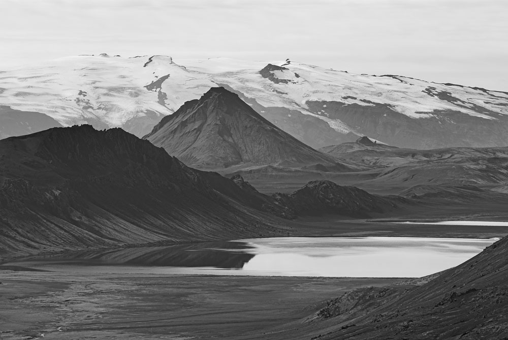
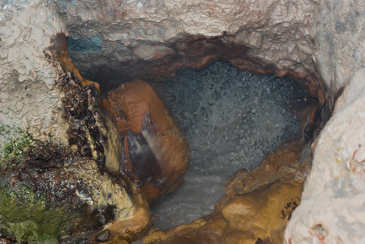
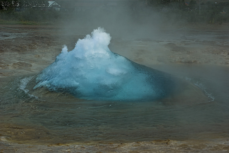
Photographs of Iceland

Laugarvegur, Iceland


Tjörnin

Fríkirkjan, the Free Lutheran Church on the bank of Lake Tjörnin. The lake in the middle of the city is less than a metre deep and the home of numerous birds.

Hallgrímskirkja

Planned in 1937, started in 1945, finished in 1986 and 73 m high it is the most remarkable building of Reykjavík. The architecture takes loan of the all-present basalt structures of Iceland. A memorial in front of the church is devoted to Leifur Eiríkson.
Church Church


Skógafoss

All waterfalls in Iceland carry the string "foss" in their names, the word is self-explaining. The river Skoga forms not only this huge fall over the edge of a former coast line. There are many more to come for those people who hike upstream, for a dayhike or, as we did, to Landmannalaugar.

Tourism

There is no need in hiking to see a waterfall in Iceland. Tourists are carried by busses on daytrips to some famous falls like Gullfoss, Skogafoss and Seljalandsfoss. The camping site in Skogar is directly in front of the waterfall, nevertheless it is much calmer in the evening than during daytime. On the other side, a large waterfall such as the Skógafoss becomes even larger with some tiny tourists as a benchmark in the foreground.
Skogafoss Skogafoss


View from the pass

The Fimmvörðuháls is a pass at about 1000 m elevation between the Mýrdalsjökull and Eyjafjallajökull glaciers. A comfortable hut built in the 1940ties provides refuge after a long but not steep ascend from Skogar. Another hut, smaller and not nearly as comfortable, sits a hundred meters lower before the pass. The tremendous view reaches till the ocean.

Þórsmörk

The beautiful valley of the Krossa river is a popular place with some real forest made of small birch trees. The place is linked with civilization by regular bus service during summer. What is highlighted by the evening sun is the descend from the Fimmvörduháls pass, with the Krossa in front.
From Fimmvorduhals Krossa Valley

Glacier

This part of the Mýrdalsjökull is named Entojökull, a tongue reaching out from the ice cap that covers the surrounding terrain of the volcano Katla. The volcano itself is entirely covered by the ice, which melts during an eruption, followed by spectacular glacier flows, also called Jökulhlaup?. The last one took place in 1918, discharging more than the Amazon river for a short period of time.

Weather

Iceland is a nice spot for rainbow photographers. The southern part is more prone to precipitation, which also explains the existence of the big glaciers there and not, as one would expect, in the north.
Sandar Rainbow


Álftavatn

The lake is seen from above the Jökultungur, direction of view to the southwest. The pyramid behind the lake is called Stórasúla, with the Mýrdalsjökull in the background. In the bottom left corner the Álftavatn huts are visible. The point where this photograph was taken is also the beginning of the fumarole fields on the way to Landmannalaugar.

Lake Alftavatn

Rhyolite

A hot spot and a rift zone feed the volcanism in Iceland by carrying basaltic magma from deep within the mantle. The colored mountains of Landmannalaugar are made from the opposite type of magma, not typical of Iceland and the result of long differentiation processes in magma reservoirs. The silicic rhyolite has a lower melting temperature compared to basaltic magma, yet exhibits a much higher viscosity, making this and the higher content of volatiles such as water the cause for more violent eruptions.

Lava dome

This lava flow erupted at the end of the 15th century near the mountain Brennisteinsalda and formed the Laugahraun, whereas "Hraun" is the Icelandic term for lava field. At the end of the flow down in Landmanalaugar are hot springs, which form a nice hot river, which in return attracts the neverending stream of tourists. The area belongs to the Torfajökull volcanic system.
Rhyolit Lava dome


Hot spring

One of the many hot springs in the area. The strong hydrothermal activity results in various forms of fumaroles, hot springs and other attractions that are better captured on video rather than on static film. Often it is interesting to hear the sound as well, sometimes frightening as if a dragon is sleeping underneath the earth. Another interesting feature would be the smell, but thanks God none of the big electronic companies has put efforts in capturing this up till now.

Crater

Yet another sign of volcanic activity is the Ljótipollur, a linked row of craters with a lake in it that was created by phreatic explosions along a fault. There are just a few distinctive stratovolcanoes in Iceland with Hekla and Snæfellsjökull as the most famous examples. Even these are not as high and steep compared to a "textbook" volcano. The often effusive volcanism in Iceland favours flat shield volcanoes, if not fissure eruptions as the one at Laki or just cinder cones like this example.
Hot spring Ljotipollur crater


Water

High precipitation due to the sea climate, glaciers that feed a constant water flow to the rivers and the high terrain is a perfect combination. Water is the energy source that still tops the hydrothermal power also used by the Icelandic people. Those who believe water to be a clean renewable sort of energy have to watch out for the severe changes caused by flooding behind a dammed river, but this is a minor concern in the scarcely populated Iceland.

Gullfoss

One of the biggest waterfalls in Iceland on the river Hvíta. The water falls down over two steps, first over an 11 m deep edge and then another 21 m into a narrow and deep cañon. Within reach of daily bus tours from Reykjavík, the waterfall is frequented by thousands of tourists every day during summer.
Gullfoss Gullfoss


Glacier

The Mýrdalsjökull is a big ice cap sitting on the elevated terrain of an active volcanic zone. The whole area is subject to strong erosion. Meltwater from the glacier tongues digs deep into the soft volcanic sediments. Tungnakvislarjökull is one of Mýrdalsjökull's flows, together with the neighbouring Krossajökull it feeds the Krossa river.

Myrdalsjokull


Geysir

"Geysir" is the name of the now inactive big geysir, and then it became the name of the phenomenon itself. The picture shows the geysir Strokkur, caught in the act, at the beginning of an eruption. A deep and thin hole filled with water, which, surrounded by hot rock, may provide conditions for a geysir. The water deep in the tube heats up to boiling temperature. As soon as it starts to boil the bubble formation leads to a decreasing pressure that propagates even more boiling, which finally ejects a certain quantity of warm water and steam up into the air. This process repeats in more or less constant cycles.
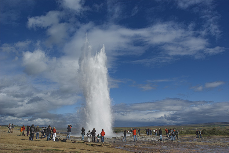
Strokkur

It is the only active geysir remaining on Iceland, after the bigger Geysir nearby had finally ceased working in 2000. The latter had never shown the same reliability as Strokkur does now, which erupts every few minutes a water column up to 30 m into the air. The application of soap into Geysir to induce an eruption was cancelled fifteen years ago, but Strokkur had also been given some human help by drilling a yet deeper hole into the geysir's vent. An eruption develops within a second, the water column already collapsing shortly after. It doesn't pose a threat to the many tourists as the water is only lukewarm.
Strokkur geysir Strokkur eruption

Keflavík

On the Reykjanes peninsula is the Icelandic gate to the outside world, the International Airport Keflavík. The nearby settlement Keflavík with nearly 8000 inhabitants is a real big town by Icelandic standard. An American air base is another economic factor, founded after WWII, after the base in Reykjavík was closed.

Whale watchers

Small vessels in the port of Keflavík are used for whale watching, a popular way of providing time, interrupted by the occasional sighting of an ocean-based geysir, originated by a whale.
Keflavik Whalewatcher ship


BACK